U.S. climate outlook for May 2024
April was another warmer-than-normal month across most of the United States, although departures were less extreme than we’ve seen in previous months this year (largest departures were “only” 3-4°F). Rainfall was mixed across the country during the month, with dry conditions in the Pacific Northwest, much of the Southeast, and parts of the central Great Plains. However, beneficial rains did fall across much of the Corn Belt and also in the Southwest. Will above-normal temperatures persist through the last month of meteorological spring? Will enough rain fall across the key agricultural parts of the nation to get the prime growing season off to a good start? Here’s what NOAA’s Climate Prediction Center (CPC) thinks will happen during May.

The temperature outlook for May 2024, showing where the average temperature is favored to be much warmer than average (orange and red), near average (gray), or much cooler than average (blues). Darker colors mean higher chances, not more extreme temperatures. White areas mean that there are equal chances for a warm, cool, or near-average May. Much warmer or much cooler than average means "in the upper or lower third" of May temperatures from 1991-2020. For more details on how to interpret these maps, read our explainer Understanding NOAA's monthly climate outlooks.
On April 30, CPC released its updated monthly climate outlooks for temperature, precipitation, and drought across the United States for May 2024. The temperature outlook favors well above average temperatures across the eastern half of the nation, with near-average temperatures favored across parts of California, Nevada, and Arizona. There is no tilt in odds over the remainder of the contiguous U.S. The precipitation outlook favors well above average precipitation across parts of the central and eastern U.S., with well below average precipitation only favored over Florida and much of New Mexico and western Texas.
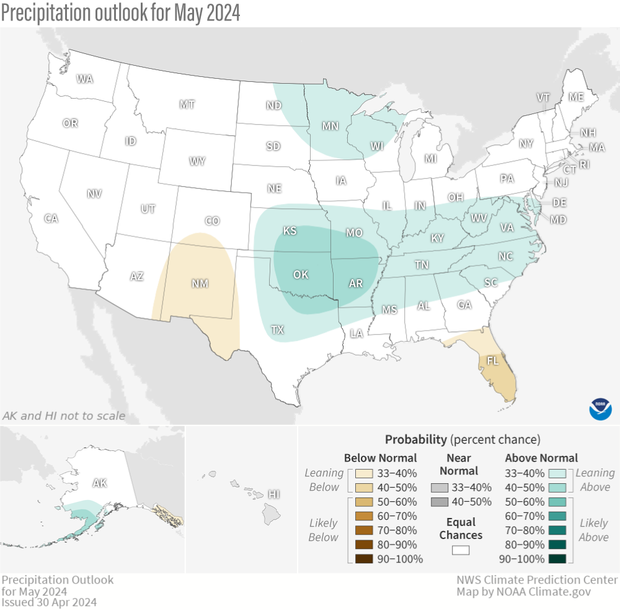
The precipitation outlook for May 2024, showing where the average precipitation (rain and snow) is favored to be much higher than average (greens), near average (gray), or much lower than average (browns). Darker colors mean higher chances, not more extreme precipitation departures. White areas mean that there are equal chances for a wet, dry, or near-average May. Much higher or much lower than average means "in the upper or lower third" of May precipitation amounts from 1991-2020. For more details on how to interpret these maps, read our explainer Understanding NOAA's monthly climate outlooks.
In addition to other details about the outlooks and their basis, I’ll also discuss the current state of drought, changes observed during April, and changes we expect to see during May. Finally, remember that the colors on the temperature and precipitation outlook maps only provide information about the most likely outcome, but other outcomes are still possible, although less likely to occur. More details about interpreting the outlooks can be found here.
The updated outlooks were produced considering the Week 1 forecast from the Weather Prediction Center (WPC), and CPC’s own Week 2 and Week 3-4 outlooks. Other tools that forecasters examined this month were longer-range forecast models such as the Global Ensemble Forecast System (GEFS), the Climate Forecast System (CFSv2), and products derived from these models. Although El Niño continued weakening during April and is expected to transition to ENSO-neutral shortly, some lingering impacts remain possible during May. Finally, observed soil moisture influenced these outlooks, as extremes in soil moisture (both wet and dry) can influence temperatures during the spring and summer.
Temperature outlook favors warmth
The May temperature outlook favors well above average temperatures across the entire eastern half of the country, from New Mexico and southeastern Colorado northeastward to Wisconsin and all points eastward. The regions most likely to be warmer than average include much of Texas, peninsular Florida and across the North from Michigan to Pennsylvania and New York, where odds all exceed 50%. No areas are favored to be colder than average, but near-average is favored in the southern half of California, southern Nevada, and extreme western Arizona.
The widespread area favored to experience above-normal temperatures leans heavily on outlooks covering the first half of the month, with most of that region expected to begin the month with well-above-average temperatures. In addition, very dry soils in west Texas and New Mexico increase the likelihood that this region will have a warmer-than-normal May. The near-average temperatures in the West were well-indicated in many monthly model forecasts, despite short and longer term forecasts all slightly favoring below-average temperatures.
Precipitation outlook is fairly uncertain
Signals for precipitation during May are quite weak, with the largest probabilities less than 50%. Above-average precipitation is favored from the central and southern Plains eastward to the Mid-Atlantic coast, with the highest odds found in the Plains. This region is predicted to get 2-3 inches of rain during the first week of the month, although outlooks for the remainder of the month are mixed. A weak tilt toward above-normal rainfall is located over eastern North Dakota, Minnesota and the western Great Lakes, as outlooks for the first half of the month favor above-average, and recent monthly CFSv2 model runs also lean wet.
Well below average precipitation is only favored over Florida and parts of the Southwest. Confidence is highest (although still modest) over Florida, where below-average precipitation forecasts are found during the first half of the month, and CPC’s Week-2 Hazards Outlook indicates a risk of rapid onset drought.
Drought area remains steady during April
Rainfall during April across the country was a mixed bag, with generally wetter-than-average conditions across parts of the Southwest and Ohio Valley, but with less-than-normal precipitation in the Pacific Northwest, central Great Plains, and Southeast. This mix resulted in the total amount of drought across the continuous United States remaining fairly steady at about 18%. Additionally, the percent of the country in the two most intense categories (D3-D4, representing extreme and exceptional drought) slipped to just under 1% at the end of April, the lowest amount since April 2020.
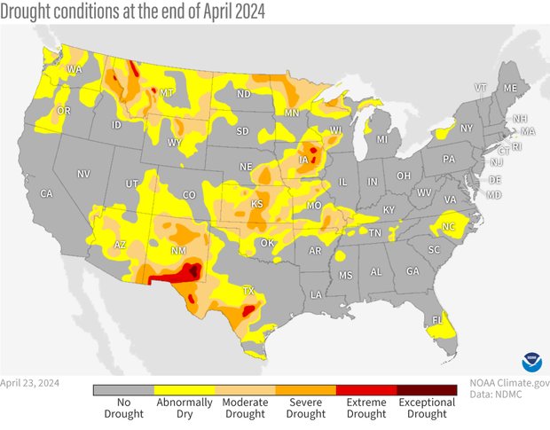
Drought conditions across the contiguous United States as of April 23, 2024. Extreme (red) and exceptional (dark red) drought was present in relatively small parts of the northern Rockies, Southwest and Corn Belt. Map by NOAA Climate.gov, based on data provided by the U.S. Drought Monitor project.
Regionally, drought degradation was most severe across western Kansas and northern Oklahoma, where changes of 2-3 classes were observed through late April. Elsewhere one class deterioration was recorded in parts of the Pacific Northwest and west-central Texas. Drought improvement, on the order of 1-2 classes, was observed across parts of the Midwest, Southwest, and northern portions of the nation. In particular, beneficial rains fell late in the month across the Corn Belt, improving topsoil moisture heading through the heart of the planting season.
Drought outlook shows a mixed bag
The drought outlook for May favors improvement (and removal) in the middle of the country, where significant rains are predicted early in the month and the May precipitation outlook also favors above-average precipitation. Persistence and even some drought development is likely in the Southwest, where above-normal temperatures and below-average rainfall are both favored.

U.S. map of predicted drought changes or persistence in May 2024. Some areas of new drought are forecast to develop across parts of Florida and drought is forecast to continue or worsen across portions of the northern Rockies and Southwest. Drought improvement and removal is likely across the central Great Plains, a small portion of Texas, and the Upper Midwest. NOAA Climate.gov map, based on data from the Climate Prediction Center.
The outlook in the northern Rockies is mixed, with mainly persistence, but some improvement in a few high elevation locations in western Montana and central Washington, regions where up to 2.5 inches of rain is expected during the first week of the month. Drought development is also likely in parts of Florida, as near-record high temperatures and below-normal rainfall early in the month should allow drought to develop over a large part of the Florida Peninsula by the end of May.
To read the entire discussion of the monthly climate outlooks from the Climate Prediction Center, check out their website.