Before the Next Flood
Previously published in the December 2010 issue of Chesapeake Quarterly.
Nick Lyons remembers when tomatoes grew in southern Dorchester County, Maryland, when bustling canning operations and crab-processing plants made Crapo and Hogsville prosperous, back before farm fields and pastures became marshes. He’s seen the waters rise since then—freak floods that are no longer freak, normal high tides pushing higher and higher.
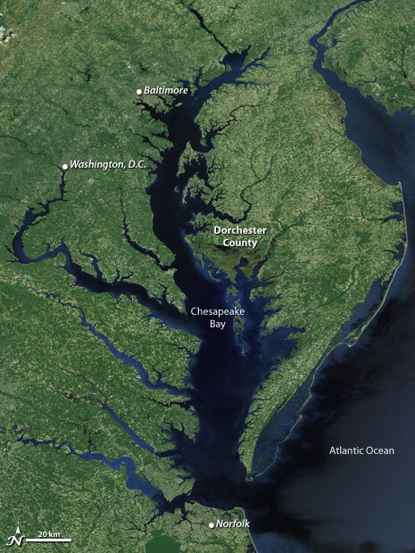
Like many places on Maryland’s Eastern Shore, Dorchester County is vulnerable to sea level rise and hurricane storm surge. (NASA image by the Scientific Visualization Studio, Goddard Space Flight Center.)
For more than 20 years, Lyons has served in the county’s executive office; he’s currently the codes administrator and floodplain manager, charged with inspecting properties and granting permits for new construction and structural renovations. For decades, he’s given the same advice to homeowners seeking permits: “Whatever you do, elevate your house out of the floodplain.”
Since the 1990s, Lyons has advocated that the county’s building codes should include elevation, or “freeboard.” The term is familiar to sailors and people who make their living around boats: it’s how far the lowest watertight deck of a ship sits above the waterline. On land, freeboard is how far the lowest floor of a house would sit above the high water line during a flood—a factor of safety that can better protect buildings from wave action, ground settling, or sea level rise.
Legislation to make this safety factor part of the building requirements has been introduced three times in the Dorchester County Council since the early 1990s; three times it’s been defeated. The bills have been voted down because of concerns over increased building costs, according to Lyons, who believes this concern is ill founded.
He says the cost increases would likely never exceed one percent of the cost of the house, and incorporating freeboard could also lead to a discount on federal flood insurance, around 20 percent, Lyons explains. “The investment is priceless, in all honesty.”
But freeboard has been a tough sell in Dorchester County. On an October evening in 2010, Lyons is preparing to make a case for it once again. The county council is conducting a public hearing on freeboard legislation, re-introduced in September. Lyons is optimistic. Bill 2010-20 would amend the Dorchester County Code by requiring all new construction and any substantial improvements to residential and commercial structures to elevate the lowest floor at least three feet above the base flood elevation.
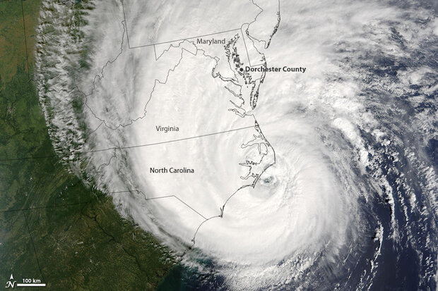
The eye of Hurricane Isabel passed south of Chesapeake Bay, but storm surge flooded many homes and businesses on the eastern shore. (NASA image from the MODIS Rapid Response Team.)
Lyons is presenting the bill. “I am going to try my best to get this through tonight,” he says. “It will be a good thing for the county. Whether they see this yet remains to be seen.”
Lyons hopes the political climate for passing freeboard legislation finally may be right in Dorchester County. This is the first time a freeboard bill has come up since Hurricane Isabel inundated the county in September 2003.
Hundreds of houses in the county were damaged by the storm and flooding. While some have since been elevated and rebuilt, many others have been abandoned.
“I think I’ll get it this time,” he says. “Isabel will be my saving grace.”
Getting above the flood
Hurricane Isabel delivered over a foot of water to the house of Harriett and Bud Hankins. Located at the head of Fishing Creek, parallel to the Little Choptank River on the eastern shore of the Chesapeake Bay, the house was built in the late 1600s or early 1700s—a new foundation was constructed in the 1940s, though it still sat flat on the ground. When the Hankins bought the house as their retirement home in 1985, the U.S. Army Corps of Engineers erected a bulkhead on one side of the property and put riprap in along the other, covering some 365 feet of waterfront. The Corps was worried about wave action and erosion because the land was at the head of the creek. Nobody said anything about elevating the house.
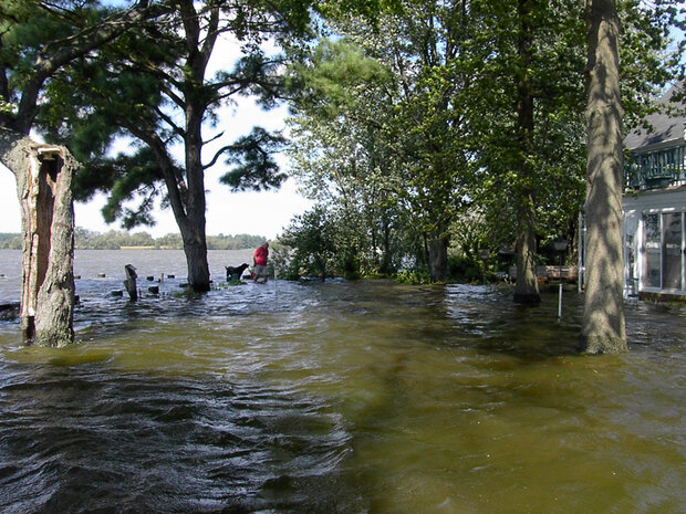
Dorchester County resident Bud Hankins wades across his front yard through the waters of Fishing Creek following Hurricane Isabel. (Photo courtesy Harriet Hankins.)
Even when the Hankins renovated their property in 1991, they heard no concerns about elevating the house, which is set back more than 30 feet from the shore. No one ever remembered water coming in.
Hurricane Isabel was another story. The water came and went quickly, according to Harriett Hankins, but left a big mark. The house flooded knee deep; after the waters receded, she and Bud began ripping sodden drywall from the sunroom. Black mold moved in immediately.
Over the next week or so, the Hankins brought in contractors who advised them not to do anything in a hurry, but to take time to dry it out completely. The contractors set up giant blowers near the foundation, while the Hankins scrubbed the kitchen with the Clorox solution recommended by the Federal Emergency Management Association (FEMA). Then they left to travel and to visit their son, who lives in Kenya. While their house back in Maryland was drying out, they were deciding whether to rebuild.
They knew the future would bring even more flooding to Maryland’s Eastern Shore. An 81-year-old retired schoolteacher, Harriett Hankins serves as a citizen representative to the Coastal & Watershed Resources Advisory Committee (CWRAC), an independent advisory body to the Secretary of Natural Resources and to Maryland’s Chesapeake and Coastal Program. She’s keenly aware of the regional predictions for sea level rise and inundation and what these predictions are likely to mean for Dorchester County.
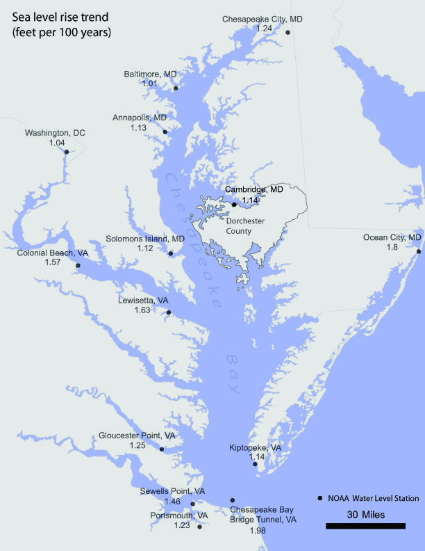
Between sinking land (subsidence) and rising waters due to global warming, sea level around Chesapeake Bay is rising faster than the global average. Based on tide gauges, scientists estimate that sea level has been rising at a rate of a foot or more per century around the Bay. (Map by Hunter Allen, based on data from NOAA’s National Water Level Observation Network.)
If land continues to sink at 20th-century rates and carbon dioxide emissions continue to increase at their current high rate, sea level around the Chesapeake Bay is projected to rise about a foot in the next 50 years—closer to three feet in the next century—based on projections from the Intergovernmental Panel on Climate Change (IPCC).* In Dorchester County, some 25,000 acres of forest (nearly 40 square miles) and 60,000 acres of wetlands (more than 90 square miles) could be lost by 2050, according to analysis (pdf) by scientists from Towson University.
Rising water will also intensify coastal flood and storm surge events. A one-foot rise in sea level means a one-foot rise in flood level. Hurricane Isabel already brought a 6-to-8 foot storm surge to the areas around the Chesapeake Bay. Climate change may increase hurricane intensity. Overlay sea level rise on top of hurricane impacts, and the picture is clear: houses on the coast grow more vulnerable each year.
When the Hankins returned from Kenya, they found that the damage to their house, although extensive, could have been much worse. Wood floors that had swelled and shifted from the flooding had settled back into place. They decided to rebuild and to elevate above the minimum requirements specified by FEMA and the state of Maryland.
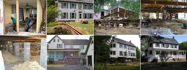
It took a year of construction (upper left to lower right) to raise the Hankins' home 4 feet—two feet above flood level. (Right-click humbnails and "save picture as" to download larger images. All photos courtesy Bud and Harriet Hankins.)
After Hurricane Isabel, FEMA required houses that sustained more than 50 percent damage to be raised above base flood elevation or they would not be eligible for flood insurance. Flood insurance is usually a necessity for houses located in a floodplain: federally backed mortgage companies will not issue loans for houses without flood insurance.
Elevating the Hankins house was no small feat (see image gallery); it took nearly a year. The age and fragility of the house precluded using heavy equipment to dig out the foundation, so contractors dug it out by hand until they could slide I-beams underneath to raise it up, one painstaking inch at a time. Then they brought in fill dirt to make up the necessary height. The Hankins chose to elevate their house by four feet. Essentially, they voluntarily incorporated a two-foot freeboard, which is what Maryland’s floodplain ordinance recommends—but doesn’t require.
The state of Maryland offered significant financial assistance to help county residents with construction costs, while mortgage companies offered very low rates. But for many, the costs were still too high, and they abandoned their houses outright. The Hankins sold another property to finance the rebuilding. They count themselves among the lucky ones.
*Original text stated sea-level rise would be “more than a foot” over the next 50 years rather than “about a foot.”
Here and Now
Do other residents along Maryland's low-lying Eastern Shore think about their vulnerability to the combined impacts of sea level rise and storms with the power of Isabel? To answer this question, anthropologist Michael Paolisso and industrial economist Matthias Ruth have been studying coastal communities, including Smithville, a rural community roughly 13 miles southwest of the Hankins' house.
Paolisso recruited members of the New Revived United Methodist Church to participate in a series of three workshops. To better understand what residents think about potential climate threats to their community, he asked participants to generate words they associate with climate change, and then the scientists studied how those words relate to each other. He also provided maps with projections for sea level rise and coastal flooding that included Smithville and the church.
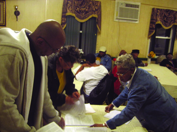
In Smithville, anthropologist Michael Paolisso worked with members of the New Revived United Methodist Church (above) to gauge their thoughts and feelings about climate change. (Photo by Michael Paolisso.)
The participants were well experienced with heavy storms and floods, Paolisso found. They knew which areas are high and whose houses were likely to flood, and they had a sense for which roads might be cut off and which members of their community might need assistance.
But when it came to their community's vulnerability, their concerns were on the here and now, not the future. Residents were interested in the maps showing projections for sea level rise and future flooding, but they never expressed a sense of urgency, Paolisso says. "On the surface, I didn't get a strong reaction of, ‘we're in trouble.' I didn't find them thinking 10 to 20 years out."
In four communities that Paolisso and Ruth have studied, including two in Massachusetts, nobody talked specifically about adapting to climate change. Most people have a perception, says Paolisso, that climate change and sea level rise are in the future and there's not much that can be done about it anyway. "I don't think people are thinking about how they or their community can adapt to climate change. Many of them have more pressing needs."
********
Seven miles south of the church, Smithville Road becomes Hooper's Island Road, eventually running between pools of water and marshes dotted with the charred-looking skeletons of evergreen trees. The trees were killed by salt water intruding inland, driven by higher than normal tides and storm surges. The road descends and flattens out then arches high across the bridge leading away from the mainland.
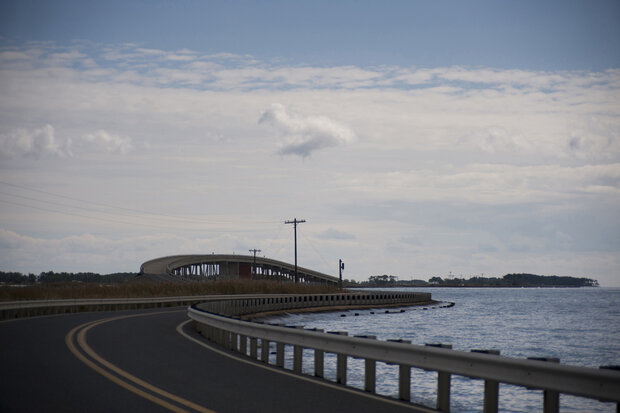
The low-lying road from the mainland to the community of Hooper’s Island briefly rises above tidal marshes and open water. (Photo by Erica Goldman.)
More than a bridge and a road connect Hooper's Island with Smithville. Here, too, residents living on the low lip of the Bay seem not to worry much about future storms and sea level rise.
On Hooper's Island, home to approximately 420 residents--many of them watermen and their families -- Hurricane Isabel left a mixed legacy. Some were able to rebuild quickly, and they elevated their houses in the process. Roughly one-third now sport new cinderblock foundations and sit a few feet higher than before. Others are only now rebuilding and elevating their houses, more than seven years after the storm; construction sites abuzz with activity punctuate quiet streets.
Meanwhile, dozens of other houses stand abandoned- paint peeling, black mold encrusting white shingles. On one side of the road, a streetlamp stands in water several feet deep. Next to it, a rusted-out metal shed. Up the road on the other side, trees and shrubs invade the façade of another house, weaving through the walls and windows an organic message of "Keep Out" to anyone who draws near.
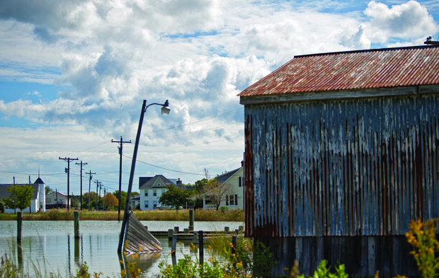
Some of the damage to homes and infrastructure on Hooper’s Island from Hurricane Isabel in 2003 has yet to be repaired. (Photo by Erica Goldman.)
Hooper's Island still houses two crab-processing plants: Ruark's and Phillips. Jay Newcomb, who manages the Phillips plant, has lived on Hooper's Island all his life. He's currently serving his second term as the Dorchester County Commissioner. He also operates Old Salty's, a restaurant on the island that among much else serves outstanding lump crab cakes.
Newcomb relates to the struggles that people face on Hooper's Island. He knows that many cannot afford to rebuild or elevate their homes. Many own their houses outright and do not have federal flood insurance. For them, as sea level rises, abandoning the island ultimately may prove their only option.
In terms of storms like Hurricane Isabel, he says that his constituents do not feel a strong sense of urgency. Most feel that Isabel was an unlucky chance event, he says, not a harbinger of worse things to come. The community is not yet thinking too much about how to adapt to changing climate conditions-how to prepare for more intense storms and rising waters. Life unfolds here one day at a time.
Planning for Rising Seas
If so few residents identify sea level rise and more intense storms as a growing risk, how can the state of Maryland help communities prepare for the future? For some time now, a number of state agencies have been working with county and local officials to incorporate the impacts of climate change in master plans of community development.
Gwen Shaughnessy, a coastal hazards and climate program specialist for the Maryland Department of Natural Resources (DNR), has helped develop the CoastSmart Communities Initiative, a NOAA-funded program aimed at helping coastal communities plan for and adapt to climate change. The program is a direct response to recommendations in the Maryland Climate Action Plan, released in 2008 (see For More Info).
Shaughnessy's efforts take a two-pronged approach. First, a technical mapping component helps pinpoint those areas most at risk -- this process incorporates data on coastal topography and combines them with projections for sea level rise and storm surges. She then works directly with local governments to incorporate this information into development planning.
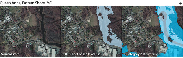
A trio of screen shots from the CoastSmart Communities online mapping tool shows inundation potential in Queen Anne, a small town on the Tuckahoe River. Areas vulnerable to a sea level rise of 2 feet or less are shown in light blue (center panel). Areas vulnerable to flooding during a Category 2 hurricane storm surge are darker blue (far right panel). These maps are not NOAA projections of sea level rise, though this range is consistent with projections from global climate models for the coming century. These images represent one of many possible future scenarios for sea level rise and storm surge flooding that users can picture using the mapping tool. (Images by Richard Rivera, based on imagery and map layers from the Maryland Coastal Atlas.)
The idea, says Shaughnessy, is that planning for climate change should not be separate from the overall planning process, but a practice of fitting it in to day-to-day business. "Local governments are charged every day with deciding where to develop, where to grow. We're trying to help them integrate into this planning the potential changes that climate change might bring."
Raising structures such as houses, utilities, and roads above the base flood elevation (freeboard) is a significant starting point, says Shaughnessy. Such practices build in a buffer, a factor of safety, especially because the projections of climate change are just that – projections. "It is difficult to draw a line in the sand and say that this is where the extent of the flooding is going to occur. So we are asking local governments to go above and beyond what is required."
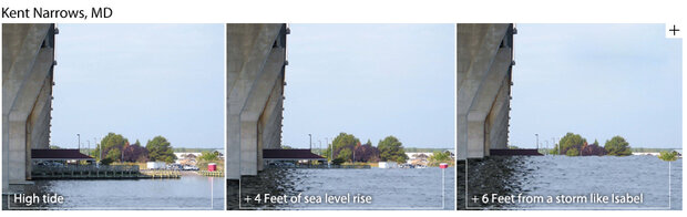
This trio of images shows the water level at a fishing pier at Kent Narrows, on Maryland’s Eastern Shore, at high tide (left); high tide with a 4-foot rise in sea level (center); and high tide with 4-foot sea level rise plus a Hurricane-Isabel-like storm surge (right). These scenarios are not NOAA projections for the area; they are simply a creative approach to helping people imagine potential impacts of long-term climate change on familiar places. (Graphics adapted from Visualizing Sea Level Rise in Maryland’s Chesapeake Bay (pdf), produced by Maryland Sea Grant and Michael Kearney, University of Maryland.)
Shaughnessy acknowledges that this is a tough sell -- local governments already are contending with a number of environmental regulations, such as new requirements that limit specific pollutant discharges by watershed (see last CQ).
One key is to recognize where opportunity fits without becoming an extra burden, says Shaughnessy. Through funding opportunities through the Coastal Zone Management Act, counties can apply for assistance to integrate climate change into ongoing planning. The town of Queen Anne on Maryland's Eastern Shore, for example, received assistance from the grant program to help complete the Water Resources Element of their state-mandated plan for growth and development.
The Water Resources Element requires counties to analyze current water supplies, wastewater treatment capacity, and pollutants as part of their master plans. Shaughnessy says , the town of Queen Anne will pioneer an attempt to integrate climate change planning into the process. They plan to use information on sea level rise and storm surge inundation to direct future growth out of high-risk coastal areas, and they will assess how climate change may impact water demand and wastewater treatment and distribution.
Redrawing the Maps
Planning for the next great flood may soon gain new urgency for Maryland's coastal communities. For the past several years, the state of Maryland, in conjunction with the Federal Emergency Management Agency, has been systematically updating Flood Insurance Rate Maps (FIRMs). The maps are used to determine whether or not a homeowner resides in a 100-year floodplain, which then sets the availability and rate for federal flood insurance.
Maryland's effort is part of a nationwide initiative to convert existing paper-based floodplain maps to digital versions, explains Dave Guignet, the state coordinator for the National Flood Insurance Program. The new, more accurate, digital maps will be compatible with other digitized geographic information like street grids, or hurricane risk maps, which will improve planning, permitting, and insurance applications.
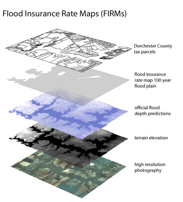
To predict flood risk and determine insurance rates, scientists make layered maps that combine local information like property tax parcels with the 100-year-floodplain boundary, model estimates of flood depth, laser-based estimates of topography and elevation, and digital photos. (Graphic by Hunter Allen, based on GIS data provided by Michael Scott, Salisbury University.)
Most states are still relying on flood elevation data from 1988 to complete the digital conversions. Maryland is out ahead, explains Guignet, in simultaneously upgrading and updating the elevation maps as part of the digitization process. These studies use the optical sensing technology LIDAR (which relies on laser pulses to find range information of a distant target) to create high-resolution digital elevation maps. Maryland's maps will also include updated data that account for rainfall, sea level rise, and erosion that have occurred in the past 20 years. They will not include any projections for future sea level rise, although these are planned for the future.
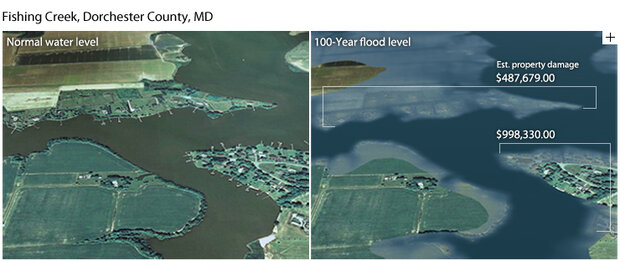
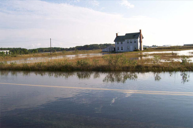
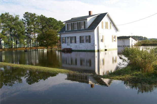
(left) Homes and docks along Fishing Creek, on Maryland’s Eastern Shore, at normal water level. (right) Water level during a once-in-a-century flood and an estimate of resulting property damage. (Images by Hunter Allen and Richard Rivera, based on Digital Flood Insurance Rate Maps and imagery provided by Michael Scott, Salisbury University.)
So far, the digital upgrades have been completed for inland areas in Maryland. The coastal maps, for counties such as Dorchester, are due to be released next yearin 2012 (Guignet corrected this). They are likely to reveal that the county's newly defined floodplain will cover even more real estate in a region where 60 percent of the residents are already living in a floodplain. More homeowners will find themselves facing high insurance rates or becoming ineligible altogether. That is without any accounting for sea level rise, which FEMA has funds to begin working on in the next two to three years.
"What do people do who find themselves in the newly-defined floodplain? What does it mean for them and their house? We've never had to go through something like this as a society," says DNR's Shaughnessy.
The pending change in floodplain maps raises the stakes for Maryland's coastal communities. Thousands of homeowners may soon find themselves facing a choice with their own properties. The economic and social consequences could prove immense.
The Fate of Freeboard
Standing before the Dorchester County Council at their October 19 meeting, Nick Lyons presents Bill 2010-20. He tells them that a three-foot factor of safety (freeboard) would have likely prevented a lot of the flood damage that county residents suffered during Hurricane Isabel. And in the past year, there have already been several days when the southern part of the county has experienced flooding, with floodwaters entering homes, according to Wayne Robinson, the emergency management director for county.
Flooding on Wingate-Bishops Head Road, Eastern Shore, Maryland, during a spring high tide, October 2007. (Photo by Wanda Diane Cole, for Sea Level Rise: Technical Guidance For Dorchester County, a report to the Maryland DNR Coastal Zone Management Division.)
Lyons also tells the Council and public attendees that adopting freeboard would reduce flood insurance rates significantly - by up to 20 percent. And this cost savings would likely offset the added costs in construction. Bud Hankins is there to validate Lyons's statement about insurance rates. After having their house elevated, he says, they received a discount on their flood insurance.
If the bill passes, Lyons adds, the Hankinses should receive yet another drop in their rates because the community as a whole would become eligible for the Community Rating System, an incentive program that rewards community floodplain management activities that exceed minimum National Flood Insurance Program requirements.
But the skeptics haven't been won over. County resident John Battista is worried about increasing the restrictions already placed on the use of resident-owned property. He would rather "risk the odds" than raise his home above base flood elevation. Property owners should be allowed to decide for themselves how much flood risk they are willing to take, he says.
Several days of heavy rain and the failure of a tidewater berm around a house on Wingate-Bishops Head Road allowed the front yard to flood during a spring high tide in October 2007. (Photo by Wanda Diane Cole, for Sea Level Rise: Technical Guidance For Dorchester County, a report to the Maryland DNR Coastal Zone Management Division.)
Concerns also arise over increasing construction costs. Councilman William Nichols from District 2 argues that imposing a freeboard requirement would place too harsh an economic burden on residents. He suspects that the end result may be an increase in building costs that will negate the insurance rate decrease. "In the current economic climate," he says, "implementing a freeboard requirement will only burden a new homeowner."
Councilman Ricky Travers from District 3 and Councilman Rick Price from District 4 agree. Travers also echoes the sentiment expressed by Battista that the decision to elevate their home should be a personal one.
The time comes for a roll call vote. Four Council members opposed, only one in favor. The Council agrees not to proceed with Bill 2010-20.
*****
Freeboard will not come to Dorchester County - at least not now. Nick Lyons is surprised and disappointed. This is the fourth time he's pushed for freeboard legislation before the County Council. This is the fourth time it has failed. He doubts that it will come up again during his tenure with the county and he's "pretty much out of steam on it."
A large number of houses already require flood insurance in Dorchester County, Lyons says. And that number will likely grow larger with the pending adoption of elevation upgrades in the new Digital Flood Insurance Rate Maps. Without freeboard, flood insurance premiums will remain high. In the end, the decision not to adopt freeboard could end up costing the homeowners of Dorchester County a lot of money.
Lyons suspects it will take another great storm like Isabel to stir up enough concern, to make people wish that they'd adopted the change when they'd had the chance. He hopes that a group of individuals will come together to bring momentum to this issue again for Dorchester County. And before it is too late.
Erica Goldman was a science writer for the Maryland Sea Grant Program when she wrote this story, which originally appeared in the December 2010 issue of Chesapeake Quarterly. She is currently the Assistant Director for Science Policy Outreach at Communication Partnership for Science and the Sea.
Editor’s note: On March 15, 2011, the County Council of Dorchester County adopted new floodplain management regulations that incorporate two feet of freeboard into the flood protection elevation. The new regulations go into effect on May 24, 2011.
More information:
Climate Change and Flooding in Maryland
Maryland Commission on Climate Change. (2008). Maryland Climate Action Plan. Available online from the Maryland Department of the Environment.
CoastSmart Communities Initiative
Digital Flood Insurance Rate Maps for Maryland
Chesapeake Bay National Estuarine Research Reserve — Maryland Coastal Training Program
National Sea Grant Climate Activities
Sea Level Rise
Meehl, G.A., T.F. Stocker, W.D. Collins, P. Friedlingstein, A.T. Gaye, J.M. Gregory, A. Kitoh, R. Knutti, J.M. Murphy, A. Noda, S.C.B. Raper, I.G. Watterson, A.J. Weaver and Z.-C. Zhao (2007). Global Climate Projections. In Climate Change 2007: The Physical Science Basis. Contribution of Working Group I to the Fourth Assessment Report of the Intergovernmental Panel on Climate Change, [Solomon, S., D. Qin, M. Manning, Z. Chen, M. Marquis, K.B. Averyt, M. Tignor and H.L. Miller (eds.)]. Cambridge University Press, Cambridge, United Kingdom, and New York, NY, USA.
Vermeer, M., & Rahmstorf, S. (2009). Global sea level linked to global temperature. Proceedings of the National Academy of Sciences, 106(51), 21527 -21532.
Climate Change & Storms
Emanuel, K. A. 2005. Divine Wind: The History and Science of Hurricanes. Oxford Univ. Press, New York, 304 pp.
Emanuel, K. A. 2005. Increasing destructiveness of tropical cyclones over the past 30 years. Nature 436: 686-688.
Webster, P. J., G. J. Holland, J. A. Curry, and H. R. Chang. 2005. Changes in tropical cyclone number, duration, and intensity, in warming environment. Science 309: 1844-1846.
Landsea, C. W. 2007. Counting Atlantic tropical cyclones back to 1900. Eos Trans. AGU 88(18):197-202.
Trenberth, Kevin E. 2007. Warmer oceans, stronger hurricanes. Scientific American 297(1):44-51.