El Niño: Fizzle or Sizzle?
El Niño: Fizzle or Sizzle?
July was a rough month for the potential development of El Niño. Waiting for El Niño is starting to feel like Waiting for Godot. As Emily discussed in her post and as the CPC also described in the August 7th ENSO discussion, the trends were in the opposite direction of El Niño, particularly with respect to the ocean. Below-average temperatures emerged at the surface in the eastern equatorial Pacific and were widespread below the surface. The appearance of seemingly unfavorable conditions has led to some comparisons with 2012, when an emerging El Niño instead collapsed. Are we in 2012 territory again? Is this El Niño again a bust?
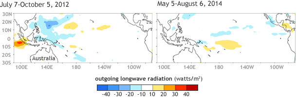
In 2012, sea surface temperatures were certainly above their normal average, but the atmosphere remained fickle. In fact, certain atmospheric features across the tropical Pacific remained more suggestive of La Niña, the opposite condition of El Niño. Namely, rainfall was above average near the Maritime Continent (north of Australia), which is a common feature associated with La Niña.

Outgoing Longwave Radiation (OLR) anomalies (departures from average) for early July - early October 2012 and for early May - early August 2014 (up to present). Blue shading indicates regions of increased rainfall, while yellow/orange shading show regions of decreased rainfall. NOAA OLR data (Liebmann and Smith, 1996) using a 1981-2010 base period. Map by Michelle L'Heureux, Climate Prediction Center.
In 2014, we have again struggled to see clear atmosphere-ocean coupling (i.e. interaction). For several months, the Niño-3.4 index (which tracks sea surface temperature anomalies in the east-central equatorial Pacific) increased, but then we saw that index lose ground in July. While the weakening is likely due to the lack of an atmospheric response, the atmosphere has not looked as La Niña-like as it did in 2012: for example, the enhanced rainfall near the Maritime Continent in 2012 is absent in 2014. In other words, while the atmosphere isn’t yet acting like El Niño, at least it’s not acting like La Niña.
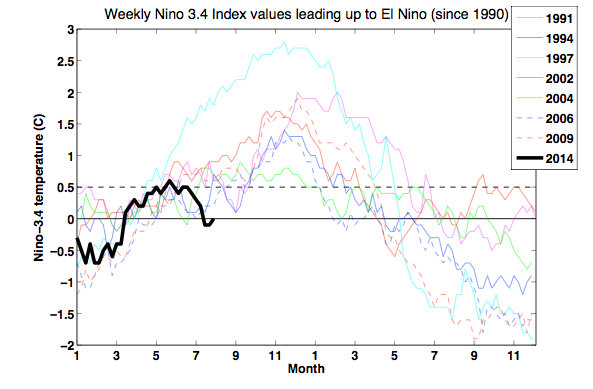
Also, this sort of summertime lull in warming in the east central equatorial Pacific is not unique when you look back at the more recent historical record. Below is the weekly Niño-3.4 index for consecutive two-year periods during which El Niño was present during the winter. The thick black line shows values since January 2014.

Two consecutive years of Niño-3.4 index values for El Niño episodes that peaked during the Northern Hemisphere winter. The thick black line shows the values of Niño-3.4 for the current year (2014) up to present. The dashed (solid) horizontal line shows where the Niño-3.4 index is equal to 0.5°C (0°C). Data based on weekly OISSTv2. Figure by Michelle L’Heureux, Climate Prediction Center.
Several times in past years the Niño-3.4 temperature anomaly index lost ground for a time after an initial increase. For example, the events starting in 1994 and 2006 had summertime lulls, but went on to become moderate-strength El Niño events (peak SST anomaly ≥ 1ºC). It is interesting that these short-lived dips occurred in the June or July time period, which seems to imply that the Northern Hemisphere summer season might be a tough time for El Niño to develop if the event hasn’t already become more firmly rooted (1).
As Emily showed, this recent decrease was predicted 1-2 months ahead of time (with certain models, like CFSv2 showing hints at a warming plateau since early May 2014). This advance notice strongly implies some models saw something in the climate system that accounts for the lull (we have speculated on one feature here).
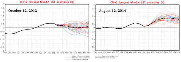
In contrast, during 2012, once the Niño-3.4 temperature index started to decrease, many models started to anticipate that El Niño was not going to occur. Currently we are waiting to see the latest runs from many of these models (see IRI/CPC’s mid-monthly update of the ENSO plume here), but we can examine NWS/NCEP’s CFSv2, which is run every day. Clearly, the CFSv2, unlike in 2012, is not favoring a bust at this point. Though some members (thin lines) suggest that outcome, so it cannot be ruled out either.

NCEP Climate Forecast System (CFSv2) predictions of the Niño-3.4 index made on October 12, 2012 and August 12, 2014. Index values greater or equal to 0.5°C (see y-axis) for consecutive seasons are considered El Niño episodes. The thick black line is the observed values of the Niño-3.4 index. The thick dashed line is the ensemble average of the individual forecast members, which are displayed as the thinner lines. Figures by Wanqiu Wang, Climate Prediction Center.
In summary, we continue to favor the emergence of El Niño in the coming months, with the peak chance of emergence around 65% (i.e. there is a 35% chance of El Niño not occurring). ENSO forecasters do not expect a strong El Niño (we can’t eliminate the chance of one either), but we are not expecting El Niño to “fizzle.” In fact, just in the last week, we have started to see westerly wind anomalies pick up near the Date Line. Literally and figuratively, we may be witnessing the start of ENSO’s second wind.
Footnote:
(1) One Northern Hemisphere summer feature is an east-west “band” of tropical rainfall that is normally positioned north of the equator. This band is called the Inter-tropical Convergence Zone (ITCZ). Because most tropical rainfall falls in this region, changes in intensity or departures in the position of the ITCZ will sometimes result in anomalies north of the equator. The formation of ENSO events, on the other hand, is usually associated with anomalies in rainfall and winds that occur directly on the equator.