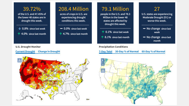
The National Integrated Drought Information System is a multi-agency partnership that coordinates drought monitoring, forecasting, and planning. It collects and integrates information on the key indicators of drought and offers usable, reliable, and timely drought forecasts and assessments of associated risks to facilitate proactive decision making. At Drought.gov, you'll find information about current drought conditions, historical drought, drought impacts, outlooks, forecasts, reports, research, events, and news at the local to international level.
Where did these data come from?
Drought.gov pulls information from a wide variety of sources and partners across the U.S. Federal government, state governments, tribal governments, municipalities, and universities, including the U.S. Drought Monitor, National Drought Mitigation Center, National Weather Service, NOAA, USDA, USGS, EPA, and regional climate centers.
-
Use the site's navigation to select information by type (current, historical, impacts, outlooks, forecasts), by sector (agriculture, manufacturing, water utilities, ecosystems, transportation, wildfire, energy, public health, hazards, recreation, tourism), by location (local, county, state, regional, watershed, tribal, national, international) or browse by topics such as flash drought, drought early warning, or soil moisture.
 Click to see more detail
