The U.S. drought vulnerability rankings are in: How does your state compare?
Details
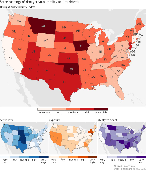
If asked where in the United States is most vulnerable to drought, you might point to those states in the West currently suffering under hot and dry conditions and raging wildfires. However, according to a new NOAA-funded assessment, what makes a state vulnerable is driven by more than just a lack of rain: it’s a combination of how susceptible a state is to drought and whether it’s prepared for impacts. And the most and least vulnerable states could surprise you.
These maps show each state’s overall drought vulnerability (red) and how it ranks in the three individual categories that make up the score: sensitivity (blue), exposure (yellow-orange), and ability to adapt (purple). Darker colors show higher overall drought vulnerability and a greater degree of factors that increase the state's vulnerability. (For the latest drought status information, visit Drought.gov.)
Sensitivity is the likelihood of negative economic impacts, which is based on the percentage of agricultural land, number of cattle, how much the state relies on hydropower, and recreational lakes. The exposure score reflects how often a state experiences drought and what assets, like the number of people and freshwater ecosystems, are at risk when it occurs. The ability to adapt score ranks how well the state can cope with and recover from drought, which depends on whether the state has a drought plan, how equipped it is to irrigate its land, and whether it is financially strong overall.
By this scoring system, the most vulnerable states are Oklahoma, Montana, and Iowa, while Delaware, Massachusetts, Connecticut, and California are least vulnerable to drought. Oklahoma gets its high vulnerability score from having an outdated drought plan and limited irrigation (low ability to adapt), as well as extensive agricultural activities and cattle ranching (high sensitivity). Despite facing recurring multi-year droughts (relatively high exposure), California ranks very low in drought vulnerability. Thanks to a strong economy and well-developed adaptation measures, it’s better prepared for an extreme drought when it occurs than most other states.
On the East Coast, the region is generally less vulnerable than other areas, given its wetter climate and lack of farming—except for New Jersey. As the most densely populated state in the country (very high exposure), it gets the region’s highest vulnerability score.
By breaking down drought vulnerability into three components, this assessment can help decision makers identify what makes their state vulnerable for better planning. And, as the study shows, even states that receive lots of rain can still be vulnerable.
Though drought is one of the costliest natural hazards in the United States, there are actions states can take to become more resilient.
This research was led by Johanna Engström, Keighobad Jafarzadegan, and Hamid Moradkhani from the University of Alabama and funded in part by NOAA’s Climate Program Office through its Modeling, Analysis, Predictions, and Projection (MAPP) program. The MAPP Program enhances our capability to understand, predict, and project variability and long-term changes in Earth’s climate system.
