ENSO Blog
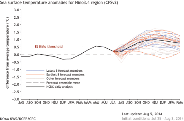
July was a rough month for the potential development of El Niño. Waiting for El Niño is starting to feel like Waiting for Godot. As Emily discussed in her post and as the CPC also described in the August 7th ENSO discussion, the trends were in the opposite direction of El Niño, particularly with respect to the ocean. Below-average temperatures emerged at the surface in the eastern equatorial Pacific and were widespread below the surface. The appearance of seemingly unfavorable conditions has led to some comparisons with 2012, when an emerging El Niño instead collapsed. Are we in 2012 territory again? Is this El Niño again a bust?
In 2…
Read article
This month’s ENSO Diagnostic Discussion starts off with “the chance of El Niño has decreased to about 65% during the Northern Hemisphere fall and early winter.” The last few months, chances were estimated to be around 80% for El Niño to have formed by the fall/early winter. So, we’ve gone from an estimated 1-in-5 chance that we won’t have an El Niño to a nearly 1-in-3 chance. However, 65% is still almost twice the climatological likelihood – that is, the long-term average of how often we experience El Niño conditions – so forecasters are still predicting El Niño will develop.
So, why the decrease in the odds of El Niño?
Last month, we discussed how the atmosphere has yet to respo…
Read article
Reading back over the many excellent (if I do say so myself) posts here at the ENSO blog, there have been several re-occurring themes—the biggest of which is that ENSO is not just an ocean phenomena but an ocean-atmospheric interaction. ENSO is no one-man act. If the ocean is Abbott, then the atmosphere is Costello; the ocean…Laverne, the atmosphere…Shirley; the ocean…Kanye, the atmosphere…Kim. And just like there would be no “Kimye” without Kanye West and Kim Kardashian, there is no ENSO event without both an atmospheric and oceanic response.
We have previously touched on both aspects of this with a post on the importance of a sea surface temperature (SST) gradient in the equatorial trop…
Read article
In the July 10 update and ENSO discussion, we said the atmospheric part of ENSO doesn’t seem to be responding to the ocean. El Niño requires that both be in sync and coupled with each other. Why is the atmosphere acting aloof to the rather warm ocean? This development may be especially surprising to folks given the rumors and speculation of a very strong El Niño that followed March’s oceanic Kelvin wave.
In June, the Bureau of Meteorology in Australia made an interesting observation that might shed light on the lack of coupling between the ocean and atmosphere (1). They pointed out that an anomalous sea surface temperature (SST) gradient was not in place across the…
Read article
While the focus of this blog is ENSO, there are other important climate patterns that impact the United States during the Northern Hemisphere winter season. We often focus on the winter season because that is the time of year many climate patterns are most prominent, and in the case of ENSO, this is the season when impacts are most predictable (1). In this post, we will define some of these other patterns and then in a subsequent post in August, we will discuss how much these patterns contribute to U.S. winter climate predictability relative to ENSO.
Long-term Trends
A major non-ENSO climate influence, which is particularly important for seasonal temperature, is long-term t…
Read article


