ENSO Blog

As we approach peak pumpkin spice latte season, we’re also closing in on the peak of the 2015-2016 El Niño, expected by forecasters to occur in the late fall or early winter.
This El Niño continues to rank among the strongest in our records, which start in 1950. The July-September 3-month average sea surface temperature (the ONI) was 1.5°C above normal, third in line behind July-September 1987 (1.6°C) and 1997 (1.7°C). The atmospheric response to the warmer-than-average sea surface temperatures is keeping pace, too: the Equatorial Southern Oscillation Index (EQSOI) is -2.2. This is second to 1997’s -2.6, and well ahead of the next two El Niños on the list (1972 and 1982, tied at -1.4).
…
Read article
This is a guest post by Dr Andrew Watkins, Leader of the Climate Prediction Services team at the Bureau of Meteorology (BoM) in Australia. As well as releasing Australia's seasonal outlooks every month, the team write the BoM ENSO updates and communicate ENSO impacts for Australia. You can follow the Bureau of Meteorology on Twitter @BoM_AU.
Australia and the US share many things. They are roughly the same size, they both sit on the Pacific Rim, and their people love sports, music, and movies, plus the odd donut. But to a climatologist, there are a number of fundamental differences.
For a start, America is in the land-heavy Northern Hemis…
Read article
The CPC/IRI ENSO forecast says there’s an approximately 95% chance that El Niño will continue through Northern Hemisphere winter 2015-16, gradually weakening through spring 2016. It’s question & answer time!
How strong is this El Nino now?
The only real way to answer this is to throw a bunch of numbers at you. Essentially, it’s “pretty strong.” The three-month, June-August average of sea surface temperatures in the Niño3.4 region (the Oceanic Niño Index) is 1.22°C above normal, via the ERSSTv4 data set. This is the third-highest June-August value since records start in 1950, behind 1987 (1.36°C) and 1997 (1.42°C).
The August average is 1.49°C, second behind August 19…
Read article
This is a guest post by Ken Takahashi, who is a research scientist at the Instituto Geofísico del Perú (IGP) and currently leads the national scientific committee ENFEN, which issues the official El Niño forecasts in Peru. This post does not necessarily reflect the views of IGP, ENFEN or NOAA.
El Niño was first identified by fisherman in the late 19th century off the coasts of Peru and Ecuador (Carranza, 1892; Carrillo, 1893). Unusually high Pacific Ocean temperatures depressed the region’s fisheries, and intense rainfall led to coastal flooding. The most extreme El Niño events, in terms of the surface warming in the eastern and central Pacific, occurred during 1982-1983 and 1997-19…
Read article
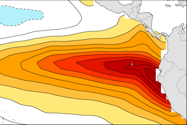
As of August, NOAA and IRI forecasters are predicting this El Niño will peak in the late fall/early winter with 3-month-average sea surface temperatures in the Niño3.4 region near or exceeding 2.0°C (3.6°F) above normal. If this forecast comes true, it will place the 2015 event among the strongest El Niños in the (admittedly short) 1950-2015 historical record. What would this mean for expected impacts in the United States?
But first, this status update!
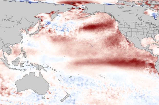
Sea surface temperature anomalies (departures from the long-term average) increased in much of the equatorial Pacific during July. The July average in the Niño3.4 region was +1.2°C above normal according to the ERSST monitoring datasets…
Read article