ENSO Blog
El Niño continued to build during June, despite some shorter-term fluctuations in the climate system (here’s looking at you, MJO). CPC/IRI forecasters are still very confident that this event will persist through the winter, and they continue to favor a strong event, with the three-month average sea surface temperature in the Niño3.4 region expected to peak at more than 1.5°C above normal.
Nearly all the computer models are in agreement, and the atmosphere and ocean continued to behave in a very El Niño-like manner. So what is there to talk about this month? Well, a few interesting things happened over the past few weeks.
First, a quick rundown of where we find ourselves in the beginni…
Read article
“El Niño is Strong!”
“No, it’s Moderate!”
“But the [insert your favorite ENSO indicator here]
is the largest it’s been since the El Niño of 1997-98!”
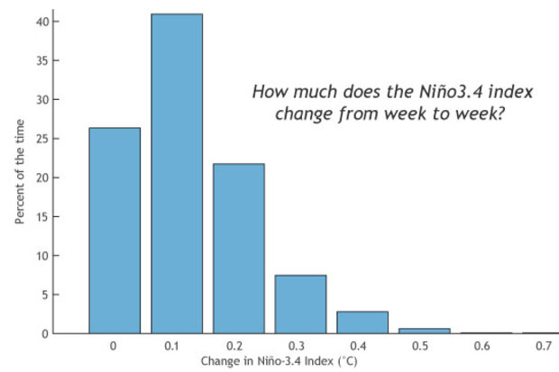
We are now nearing 1.5 degrees Celsius in the Niño-3.4 index for a 7-day or weekly average. Among the post-college age crowd who can remember it (yes, this officially means you’re old), the level of warmth in sea surface temperatures this time of year harkens back to 1997-98 El Niño, which ended up becoming a record strength event.
Are these weekly numbers impressive? Yes. But when a weekly value hits 1.5°C is El Niño instantly considered strong? I’d argue no. While a short-term (daily or weekly) number might be striking, i…
Read article
...but it's still a seasonal forecaster's best friend.
After El Niño conditions were declared in March and Climate Prediction Center’s latest forecast predicted El Niño’s continued strengthening during the upcoming summer and fall, I think it is safe to say we are well within the time period where everything will be blamed on El Niño.
It rained on your wedding day? El Niño. Had an outdoor picnic ruined by a late afternoon thunderstorm? El Niño. Was it hot …during the summer? El Niño.
Usually these are exaggerations. Mike Halpert and Tony Barnston in past posts have shown what type of U.S. and global impacts are associated with an El Niño for the late fall and winter and for the summ…
Read article
El Niño continues to pick up steam. NOAA CPC/IRI forecasters are now very confident that the event will continue through the fall (over 90% chance) and into the winter (~85% chance). Now that we’re emerging from the spring barrier, this month’s update provides a first guess of the potential strength of El Niño. It’s harder to predict the strength of the event than it is to predict its duration, so we are less confident about that, but forecasters currently favor a “strong” event for the fall/early winter. By “strong” we mean it’s expected that the three-month average sea surface temperature in the Niño3.4 region will peak at more than 1.5°C (2.7°F) above normal.
What’s happening right now…
Read article
In the recent ENSO Diagnostic Discussion, the probability of El Niño during this Northern Hemisphere summer (June to August) exceeds 90%. As of late May, weak to moderate El Niño conditions are already here, both in the oceanic and atmospheric aspects. And many ENSO prediction models are calling for the sea surface temperature (SST) anomalies to increase during the next several months.
Usually, El Niño or La Niña episodes attain peak strength in autumn or early winter (1), and climate impacts in the mainland US are most reliable during winter—just a bit later than peak time. Last June, Mike Halpert described the expected effects of El Niño in the US during winter. But because the Nino3.4 …
Read article


