
Home to 13 of the 20 largest metropolitan areas in the United States, our nation’s coasts face hurricanes, sea level rise, coastal erosion, natural resource depletion and more. A new white paper lists ways to better understand these complex, vulnerable ecosystems.
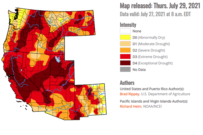
In response to the record-breaking drought, the National Integrated Drought Information System (NIDIS) joined federal, state, tribal and local partners in hosting a drought webinar specifically for western communities on July 20. The webinar, which now has a summary and recording available, provided the latest information on drought conditions and federal response efforts.

For the first time, California’s Fourth Climate Change Assessment included nine regional reports, including reports on San Diego and Sierra Nevada. The California Nevada Climate Applications Program evaluated the regional reports’ development and use.
Lessons learned from Hurricane Harvey may help disaster professionals better support preparing for extreme events across the United States. A new report offers insights for businesses and nonprofits in Port Arthur and Beaumont, Texas.
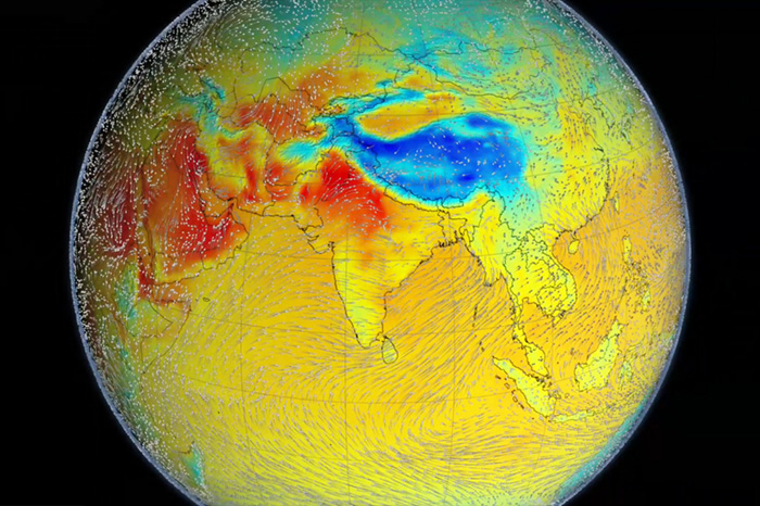
Among the most important summer climate events in the Northern Hemisphere, the South Asian summer monsoon affects more than a billion people. A new study measures how changes in global mean surface temperature will affect the monsoon.
Nitrogen oxide is an air pollutant with health and environmental consequences, so researchers try to accurately gauge human-caused NOx emissions. Emission inventories and satellite observations have given different estimates of NOx. A new study shows the source of the discrepancy

Human activity has driven a positive trend in Earth’s energy imbalance, increasing the planet’s heat storage. This is the conclusion of a new study by Princeton University and NOAA researchers.

NOAA has worked with the American Planning Association to produce a new report proposing a framework for climate resilience planning in the San Diego region. Some of the threats covered in the report are unique to the region; some threats have already happened in other U.S. regions.

The latest version of the U.S. Climate Resilience Toolkit’s Climate Explorer now offers climate projections for every county in the entire United States. The recent addition of climate projection data for Hawai'i and U.S. island territories in the Pacific Ocean and Caribbean Sea complements the tool’s original contiguous U.S (CONUS) coverage and the addition of data for Alaska in 2020.

Besides implications for air quality and health, wildfires affect climate. A study designed to uncover the climate effects of wildfire smoke found that smoke from wildfires in the western United States absorbs less sunlight than smoke from wildfires in southern Africa.