September 2015 El Niño Update and Q&A
The CPC/IRI ENSO forecast says there’s an approximately 95% chance that El Niño will continue through Northern Hemisphere winter 2015-16, gradually weakening through spring 2016. It’s question & answer time!
How strong is this El Nino now?
The only real way to answer this is to throw a bunch of numbers at you. Essentially, it’s “pretty strong.” The three-month, June-August average of sea surface temperatures in the Niño3.4 region (the Oceanic Niño Index) is 1.22°C above normal, via the ERSSTv4 data set. This is the third-highest June-August value since records start in 1950, behind 1987 (1.36°C) and 1997 (1.42°C).
The August average is 1.49°C, second behind August 1997 (1.74°C). The August Equatorial Southern Oscillation Index (which measures the strength of the atmospheric part of ENSO) was -2.2, second to 1997’s -2.3. There are many ways of measuring El Niño, so the ranking of El Niño will change depending on which variable (winds, pressure, etc.) or time period (monthly, seasonal) you want to examine.
When is El Niño going to hit?
El Niño isn’t a storm that will hit a specific area at a specific time. Instead, the warmer tropical Pacific waters cause changes to the global atmospheric circulation, resulting in a wide range of changes to global weather. Think of how a big construction project across town can change the flow of traffic near your house, with people being re-routed, side roads taking more traffic, and normal exits and on-ramps closed. Different neighborhoods will be affected most at different times of the day. You would feel the effects of the construction project through its changes to normal patterns, but you wouldn’t expect the construction project to hit your house.
Okay, then… but what’s going to happen in my home town?
The expected changes in regional weather patterns due to El Niño are a big part of the NOAA Climate Prediction Center’s seasonal forecasts. Over North America, the Pacific jet stream (a river of air that flows from west-to-east) often expands eastward and shifts southward during El Niño, which makes precipitation more likely to occur across the southern tier of the United States. Check out the winter (December-February) forecasts here.
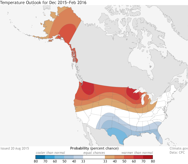
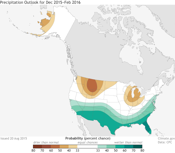
Chances of possible temperature (upper map) and precipitation (lower) outcomes for December 2015-February 2016: above normal, below normal, or near normal. Above or below normal means temperatures in the upper or lower third of the range of historical temperatures. White does not mean "near normal;" it show places where the chances for above-, below-, and near-normal temperatures are equal. Maps by NOAA Climate.gov, based on data from the Climate Prediction Center.
Why winter?
The weather in the winter is controlled more by global atmospheric flow than summer weather is, when small-scale events like thunderstorms tend to be more important. Since El Niño’s remote effects are felt though its modulation of global flow, winter is when the most noticeable impacts occur.
Winter in the Southern Hemisphere is just winding down. Did El Niño have an impact on their winter?
A few months ago, Tony wrote about expected effects of El Niño during June-August. Most of the El Niño-related changes that have been identified during past events are in the Southern Hemisphere during their winter; there are also significant effects in the tropics. These include warmer weather in some areas of South America, dry conditions in India, Indonesia, and Australia, and warm and dry conditions in Central America and the Caribbean. Also, more rain than average in part of Chile, and some cooler temperatures in part of Australia.
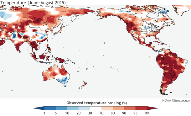
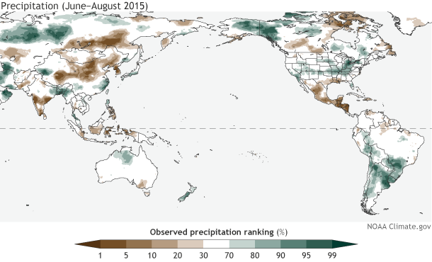
Observed temperature (upper map) and precipitation (lower) from June-August 2015. Observations are shown as their ranking in the period 1948-present: for example, a 90th percentile temperature means this June-August was warmer than 90% of the past June-August averages. Climate.gov figure from CPC data.
Much of South America did experience a very warm winter; in some areas, it was the warmest winter since these records began in 1948. Parts of Argentina, Uruguay, and Chile received a lot of rain during July-August. Central America and the Caribbean are very dry right now, with the June-August rainfall deficit just adding to a severe drought throughout the region. Also in line with expected conditions during El Niño, rainfall in some portions of India and Indonesia were well below average, and very few areas in this region saw more rain than average.
However, as we’ve said before (here and here, for example), El Niño impacts are not guaranteed, and an example of this is Australia’s recent winter, which was not nearly as dry as it has been during past El Niños.
What about the places that are directly affected by all that warm water? I heard the surface temperatures were more than 90°F in some places!
The warmer-than-average tropical Pacific waters can have a big impact on marine life. For example, there were large coral bleaching episodes (coral die-offs) during past El Niños, and it’s likely we’ll see a lot of coral bleaching this year. The warmer water can also affect fisheries, seaweed farms, ocean mammals, and birds.
What about the hurricane season? That’s supposed to be affected by El Niño, right?
El Niño can amp up the hurricane season in the Pacific, by providing lots of warm water to power the storms, and reducing the vertical shear (the change in wind speed/direction as you go up in the atmosphere). On the other hand, the shear is increased over the Atlantic, which makes it difficult for storms to form and strengthen. So far this year, the Pacific has been very active, and the Atlantic has been pretty quiet. There have been some unusual events in both basins recently – Tom wrote about them here and here.
Could El Niño die before this winter?
It’s unlikely. There is a large reservoir of warm water just below the surface of the tropical Pacific that will help to keep surface temperatures relatively high for at least a few more months, and the atmosphere is in sync with the ocean. However, the strength of the atmospheric response over the next few months is still to be determined. In 1997, the near-surface winds along the equatorial Pacific weakened so much that they reversed from normal, and blew from the west to the east, helping to reinforce the warm sea surface temperatures. We haven’t seen behavior like that yet, and it’s hard to predict right now if we will.
I keep hearing how the “Blob” (a large area of warm ocean temperatures off the West Coast of the U.S.) is going to be in a battle with this strong El Nino this winter. Which one will win?
El Nino and “the Blob” are not on an equal playing field, so the short answer is we expect El Niño to dominate the large-scale atmospheric pattern over the Pacific-North America this coming winter.
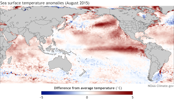
Sea surface temperatures during August compared to the 1981-2010 average. Climate.gov figure, based on data from NOAA View.
The Blob is not capable of changing the overlying atmospheric pattern in a significant way. In the Tropics, changes in ocean temperatures can easily lead to changes in the atmosphere above it. But outside of the Tropics, such as over the North Pacific Ocean, the physics are different, so ocean temperatures can’t effectively change the large-scale atmospheric flow or circulation pattern. The amount of heat in the Tropics is an enormous engine that drives rising motion and affects the whole globe’s circulation; the Blob is like a Fisher Price Power Wheel in comparison.
That said, the way that El Niño might affect water temperatures off the West Coast, or how those water temperatures might affect storms that are steered into the area by El Niño, is really hard to tell. As with any forecast, there are a lot of elements at play. However, El Niño is the dominant factor shaping the overall global picture for this winter.
Are you really naming El Niño?
No. That was a joke!
Comments
Can Northern Hemisphere destabiblise Elnino?
RE: Can Northern Hemisphere destabiblise Elnino?
Unfortunately, one of the strongest relationships between El Nino and rainfall occurs in Indonesia/Papua New Guinea, and so predictions favor drier than average conditions continuing into at least early 2016. One resource for seaonal outlooks for your region is available on the IRI page:
http://iri.columbia.edu/our-expertise/climate/forecasts/seasonal-climate-forecasts/
With that said, no climate prediction is ever guaranteed (100% chance).
How much South East Asia in affected?
RE: How much South East Asia in affected?
The link provided above might help. In general, southeast Asia has a slight tendency toward drier conditions during El NIno within the Northern Hemisphere fall and winter.
Additional 2015 El Nino Forecasting and discussion
how is gonna affect el NIÑO in Europe
RE: how is gonna affect el NIÑO in Europe
The relationship between El Nino and European climate is not clear. There is some research that indicates that if El Ninos coincide with a sudden stratospheric warming then that could enhance chances of below-average temperatures over Europe (see work by Ineson and Scaife and Butler et al.). Here is a recent blog post by the folks at UKMet that may also be useful.
Global Warming
RE: Global Warming
As our colleagues at our sister blog, Beyond the Data, will tell you, 2015 has already been a remarkable, record year for global temperatures so far.
SoCal and Central America El Niño predictions
RE: SoCal and Central America El Niño predictions
We can't tell you exactly when the rainfall will occur, but we can tell you that the greatest chance for above-average rainfall is currently during the January-February-March season (the average of all three months). For other countries, check out the IRI outlook (provided globally). Costa Rica/Panama does not have a significant connection with El NIno during Dec-Jan because that is when they typically have their dry season.
Maps
Impact on Southern California
RE: Impact on Southern California
Hi Oliver,
Thanks for your comment! We know that many are very interested in the outcome of the winter season in California in terms of rain and snowfall. The latest forecast from the Climate Prediction Center has southern california at over a 50% chance that seasonal (Dec-February) precipitation totals will be above-normal.
El Nino?
California desperate for drought relief
RE: California desperate for drought relief
Although California (especially southern) has a greater chance for good rains this El Nino winter than during an average winter, it is not guaranteed. To see how California fared during past El Nino winter, spanning from the stongest El Nino to the weaker ones, see the blog piece by Mike Halpert from last year: https://www.climate.gov/news-features/blogs/enso/united-states-el-ni%C3…
Note that although most strong events do bring good rains to California, not all of them did. The chances are pretty good that at least southern California, and possibly central and northern, could get good rainfall in the coming 5 to 6 months. The Government still does not want any more water unnecessarily used (or wasted) than necessary.
Besides increased chances for heavy rainfall in California, the same is true for most of the remainder of the southern US, all the way from Arizona through Texas, through Florida. What happens in Oklahoma and Texas does not necessarily also happen in California, although both places are likely to have wet winters, or at least not dry ones. The season of most likely effect in the south-central US is Dec through March, while in California it has tended to be more from Jan thorugh mid-April, just a bit later. Some of the storms that bring rain to California may continue eastward and affect Texas and then maybe even Florida in the following days. But some storms may affect one place without also affecting the other.
Yes, El Nino involves a weakening of the trade winds along the equator in the Pacific Ocean. This has been happening quite a bit during the last couple of months. All symptoms of El Nino that are expected in the tropica Pacific, both ocean and atmosphere, are being observed. This is not a "partial" event.
Bottom line: Your prospects for a good rainy season are quite favorable this year, especially if you are in the southern part of the state, but also if you're in the central part. Just study those maps in Mike Halpert's blog (again, https://www.climate.gov/news-features/blogs/enso/united-states-el-ni%C3…).
Drought in the Southwest
RE: Drought in the Southwest
I don't have an exact prediction for Lake Mead's water level, and of course such a prediction would be risky, given the uncertaity of El Nino's effects in the region. But prospects are good for decent, and maybe even quite heavy, rainfall during the coming 6 months in your region, which would help refill Lake Mead. Please see my reply to "Sunday" above, who has asked the same sort of question but for southern California rainfall. The answers are similar for Lake Mead to what they are for southern and central California.
ElNino
RE: ElNino
If you have been starting to get more storms tracking inland from the Pacific in northern California, then yes, you would be expected to get some above average high tide levels. I'm assuming that this has been the case. I saw some decent rain-makers affecting California during the last week or two, but do not remember just where they came ashore. I'm hoping that with this strong El Nino, northern California will benefit from greater than average winter rain, not just southern and central California, as often happens in more moderate El Nino events.
cruises
RE: cruises
It probably will not afffect scheduled cruises, other than to result in a greater number of cloudy, rainy and/or somewhat windy days during the cruise, making a less pleasant and picturesque cruise experience. I don't know to what extent cruises adjust their routes and schedules due to short-term weather forecasts; I suspect these "extra" storms coming into Califonia from the west would not significantly affect them. If one or two of the storms are particularly strong, the schedule or route might be adjusted somewhat; I don't know for sure. Most of the storms are not a danger, just an annoyance.
El Nino
RE: El Nino
Unfortunately, northern Calif typically has a smaller chance for above-normal winter rainfall than central and southern Calif during El Nino. But the very strongest ones, such as 1982-83 and 1997-98, do bring excess rainfall as far north as northern Calif and even Oregon. This El Nino might be as strong as these, at least the 1982-83 event. The official forecast for Dec-Feb and Jan-Mar 2016 from Climate Prediction Center calls for just a very slight increase in the odds for above-normal rainfall for northern California. I wish you would get some good rains in the next 6 months. There is some hope.
Effect on Africa
RE: Effect on Africa
Stay tuned... this month's update post will feature some information about El Nino in Africa.
Still Waiting....
Aftermath?
RE: Aftermath?
Good question. We expect El Nino to transition to ENSO-Neutral by late spring/early summer. For the US, we know that impacts are most reliably felt during the winter. It is still too early to say what next winter may look like or if ENSO is in a neutral state or otherwise.
The Review
Frame Walker
Why was september in 2015 so hot?
John
great staff very informative
Add new comment